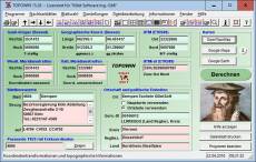
TOPOWIN is a state-wide register of the German Topographic Cartographies, the German Basic Cartography and of localities with geo references in different coordinate systems. It is also a topographic information system. In the division of planning and execution of economical and scientific projects frequently topographic documents are used. The program TOPOWIN makes information available of the official topographic cartographies and the German Basic Cartography from the entire national territory in suitable graphic views. It accomplishes different coordinate transformations and inquiries. The program was developed under co-operation of the land surveying authorities of many German Federal States. For the first time in the previous version TOPO (for DOS) and later in TOPOWIN state-wide topographic information were arranged for the data technical evaluation. The program is for consulting engineers, planning authorities and users of topographic maps a useful and versatile tool. The topographical maps of different standards, required for a project, can be determined by the entering of known parameters or by the direct selection from overview graphics and from sorted lists. By the investigation of topographical records on the basis of known places, a data base with more then 105.000 places and residential districts is available. The program TOPOWIN calculates with Gauss Krueger coordinates and Geographic Coordinates refering to the Potsdam Datum (Bessel ellipsoid with central point Rauenberg). It also works with UTM coordinates and UTMRef coordinates in the NATO standard, which refer to the datum ETRS89 (GRS80 / WGS84, geocentric).
TOPOWIN ist ein staatsweites Register der Deutschen Topographischen Kartenwerke, des Grundkartenwerks und der Ortschaften mit Georeferenzen in verschiedenen Koordinatensystemen. Es ist auch ein topographisches Informationssystem. Im Bereich der Planung und Ausführung wirtschaftlicher und wissenschaftlicher Projekte kommen häufig topographischen Unterlagen zur Anwendung. Das Programm TOPOWIN stellt Informationen der Amtlichen Topographischen Kartenwerke und des Deutschen Grundkartenwerks aus dem gesamten Staatsgebiet in geeigneten graphischen Ansichten zur Verfügung. Es führt verschiedene Koordinatentransformationen und Recherchen durch. Das Programm ist unter Mitwirkung vieler Landesvermessungsbehörden entwickelt worden. Zum erstenmal sind in der Vorgängerversion TOPO (für DOS) und später in TOPOWIN bundesweit topographische Informationen zur datentechnischen Auswertung zusammengestellt worden. Das Programm ist für Ingenieurbüros, Planungsämter und Benutzer Topographischer Karten ein nützliches und vielseitiges Werkzeug. Die für ein Projekt benötigten topographischen Karten verschiedener Maßstäbe können durch die Eingabe von bekannten Kriterien in ein Datenfenster oder durch die direkte Auswahl aus einer Übersichtsgraphik und aus vielen sortierten Listen ermittelt werden. Zur Ermittlung von topographischen Unterlagen anhand einer Ortschaft steht eine Datenbank mit mehr als 105.000 Ortschaften und Wohnplätzen zur Verfügung. Das Programm TOPOWIN rechnet mit Gauß-Krüger-Koordinaten und geographischen Koordinaten, die sich auf das Potsdam Datum (Bessel-Ellipsoid mit Zentralpunkt Rauenberg) beziehen. Es arbeitet auch mit UTM-Koordinaten und UTMRef-Koordinaten nach dem NATO-Standard (Meldefeld), die sich auf das Datum ETRS89 (GRS80 / WGS84, geozentrisch) beziehen.
TOPOWIN est un registre d'État à l'échelle de la Cartographies topographiques allemand, la cartographie de base allemand et des localités avec geo références dans différents systèmes de coordonnées. C'est aussi un système d'information topographique. Dans la division de la planification et l'exécution des projets économiques et scientifiques souvent documents topographiques sont utilisés. Le programme TOPOWIN rend information disponible des cartographies topographiques officielles et la cartographie de base allemand de l'ensemble du territoire national dans les affichages graphiques appropriés. Il réussit les enquêtes et les différentes transformations de coordonnées. Il calcule les coordonnées du coin des lignes de feuille norm de la catographies TK25, TK50, TK100 et TKÜ200 de Gauss-Krueger, UTM et coordonnées géographiques. Le programme a été élaboré dans le cadre de la coopération de l'autorités des Länder de l'arpentage. Pour la première fois dans la version précédente TOPO (de DOS) et plus tard dans l'information topographique à l'échelle état TOPOWIN ont été organisées pour l'évaluation technique des données. Le programme est d'ingénieurs-conseils, planification des autorités et des utilisateurs de cartes topographiques un outil utile et polyvalent. Les cartes topographiques des différentes normes, requis pour un projet, peuvent être déterminés par la saisie des paramètres connus ou par la sélection directe de graphiques de présentation et de listes triées. Par l'enquête des documents topographiques sur la base des lieux connus, il existe une base de données avec plus de puis 105.000 lieux et quartiers résidentiels. Le programme TOPOWIN calcule avec les coordonnées de Gauss Krueger et coordonnées géographiques se référant à la référence de Potsdam (ellipsoïde de Bessel avec Rauenberg de point central). Il collabore également avec les coordonnées UTM et coordonnées UTMRef en standard, de l'OTAN, qui se réfèrent à référence ETRS89 (GRS80 / WGS84, géocentrique).
TOPOWIN is een staat-breed register van de Duitse topografische cartografieën, de Duitse Basic cartografie en plaatsen met geo verwijzingen in verschillende coördinatensystemen. Het is ook een topografische informatiesysteem. In de divisie van planning en uitvoering van economische en wetenschappelijke projecten vaak worden topografische documenten gebruikt. Het programma TOPOWIN maakt informatie beschikbaar voor de officiële topografische cartografieën en de Duitse Basic cartografie van het gehele nationale grondgebied in geschikte grafische weergaven. Het volbrengt verschillende coördinaat transformaties en onderzoeken. Het berekent de coördinaten van de hoek van de norm blad lijnen van de catographies TK25, TK50, TK100 en TKÜ200 in de Gauss-Krueger, UTM en geografische coördinaten. Het programma werd ontwikkeld onder de samenwerking van het land surveying autoriteiten van vele Duitse federale staten. Voor de eerste keer in de vorige versie TOPO (voor DOS) en later in TOPOWIN staat-wide topografische informatie werden georganiseerd voor de technische evaluatie van de gegevens. Het programma is voor de raadpleging van ingenieurs, planning autoriteiten en gebruikers van topografische kaarten een nuttig en veelzijdig hulpmiddel. De topografische kaarten van verschillende normen, die van een project, kunnen worden bepaald door het invoeren van bekende parameters of door de directe selectie uit overzicht graphics en gesorteerde lijsten. Door het onderzoek van topografische records op basis van bekende plaatsen is een databank met meer dan 105.000 plaatsen en woonwijken beschikbaar. Het programma TOPOWIN wordt berekend met de Gauss-Krueger coördinaten en geografische coördinaten verwijst naar de Datum van Potsdam (Bessel-ellipsoïde met centrale punt Rauenberg). Het werkt ook met UTM coordinaat en UTMRef coördinaten in de NAVO standaard, die naar de datum ETRS89 verwijzen (GRS80 / WGS84, geocentrisch).
TOPOWIN è un registro a livello statale delle cartografie topografiche tedesco, la cartografia di base tedesca e delle località georeferenziate in diversi sistemi di coordinate. Esso è anche un sistema di informazioni topografiche. Nella divisione della pianificazione ed esecuzione di progetti economici e scientifici frequentemente topografiche documenti sono utilizzati. Il programma TOPOWIN rende disponibili le cartografie topografiche ufficiale e la cartografia di base tedesco informazioni da tutto il territorio nazionale nelle visualizzazioni grafiche adatti. Esso compie diverse trasformazioni coordinate e inchieste. Consente di calcolare le coordinate dell'angolo delle linee di norma foglio della catographies TK25, TK50, TK100 e TKÜ200 in Gauss-Krueger, UTM e coordinate geografiche. Il programma è stato sviluppato nell'ambito della cooperazione della terra d'esame delle autorità di molti Stati di federale tedesco. Per la prima volta in versione precedente TOPO (per DOS) e poi in informazioni topografiche di TOPOWIN a livello statale sono stati organizzati per la valutazione tecnica dei dati. Il programma è per consulting engineers, progettando le autorità e gli utilizzatori di mappe topografiche uno strumento utile e versatile. Le mappe topografiche di norme diverse, necessarie per un progetto, possono essere determinate inserendo i parametri noti o dalla selezione diretta da grafica panoramica e da elenchi ordinati. Dall'inchiesta di topographical record sulla base dei luoghi conosciuti, una base di dati con più poi 105.000 luoghi e quartieri residenziali è disponibile. Il programma TOPOWIN calcola con coordinate Gauss Krueger e coordinate geografiche si riferisce alla riferimento Potsdam (ellissoide di Bessel con Rauenberg punto centrale). Funziona anche con coordinate UTM e coordinate UTMRef nella NATO standard, che si riferiscono alla ETRS89 di riferimento (GRS80 / WGS84, geocentriche).
TOPOWIN é um registo de todo o estado do alemão topográfico cartografias, a cartografia básica alemã e de localidades com geo referências em diferentes sistemas de coordenadas. É também um sistema de informação topográfica. Na divisão de planejamento e execução de projetos econômicos e científicos com freqüência são utilizados documentos topográficos. O programa TOPOWIN disponibiliza informações das cartografias topográficas oficiais e a cartografia básica alemão de todo o território nacional nas vistas gráficos adequados. Ele realiza consultas e transformações de coordenadas diferentes. Ele calcula as coordenadas do canto das linhas de folha de norma de catographies TK25, TK50, TK100 e TKÜ200 em Gauss-Krueger, UTM e coordenadas geográficas. O programa foi desenvolvido no âmbito da cooperação da terra Agrimensura autoridades de muitos Estados de Federal alemão. Pela primeira vez na versão anterior TOPO (para DOS) e mais tarde em TOPOWIN todo o estado topográficas informações foram organizadas para a avaliação técnica dos dados. O programa é para engenheiros, autoridades e usuários de mapas topográficos um útil e versátil ferramenta de planejamento de consultoria. Os mapas topográficos das diferentes normas, necessários para um projeto, podem ser determinados inserindo parâmetros conhecidos ou Seleção direta de gráficos de visão geral e de listas ordenadas. Através da investigação de registros topográficos de lugares conhecidos, está disponível uma base de dados com mais então 105,000 lugares e distritos residenciais. O programa TOPOWIN calcula com coordenadas de Gauss Krueger e coordenadas geográficas referindo o Datum de Potsdam (elipsóide de Bessel com Rauenberg ponto central). Ele também funciona com UTMRef coordenadas pela OTAN padrão, que se referem o datum ETRS89 e coordenadas UTM (GRS80 / WGS84, geocêntrico).
TOPOWIN es un registro de todo el estado de las cartografías topográficas alemán, la Cartografía básica alemana y de las localidades con geo referencias en diferentes sistemas de coordenadas. También es un sistema de información topográfica. En la División de planificación y ejecución de proyectos económicos y científicos con frecuencia se utilizan documentos topográficos. El programa TOPOWIN pone a disposición de las cartografías topográficas oficiales y la Cartografía básica alemana información de todo el territorio nacional en las vistas de gráficos adecuados. Realiza investigaciones y transformaciones de coordenadas diferentes. Calcula las coordenadas de la esquina de las líneas de hoja de norma de la catographies TK25, TK50, TK100 y TKÜ200 de Gauss-Krueger, UTM y las coordenadas geográficas. El programa fue desarrollado en cooperación de la tierra agrimensura autoridades de muchos Estados Federados de Alemania. Por primera vez en la versión anterior TOPO (para DOS) y después en información topográfica TOPOWIN en todo el Estado se organizaron para la evaluación técnica de datos. El programa es para asesoría de ingenieros, autoridades y usuarios de mapas topográficos de planificación una herramienta útil y versátil. Los mapas topográficos de diferentes estándares, requeridos para un proyecto, pueden determinarse introduciendo parámetros conocidos o la herramienta Selección directa de gráficos de resumen y de listas ordenadas. Por la investigación de los registros topográficos de lugares conocidos, existe una base de datos con más entonces 105.000 lugares y barrios residenciales. El programa TOPOWIN calcula con coordenadas Gauss Krueger y referencia de coordenadas geográficas para la referencia de Potsdam (elipsoide de Bessel con Rauenberg de punto central). También funciona con coordenadas UTM y coordenadas de UTMRef en la OTAN estándar, que se refieren a los datos de referencia ETRS89 (GRS80 / WGS84, geocéntrica).
Program is faster and more stable using a new development system. All databases actualized on 1st. January 2021. Territorial Reform in Thuringia of the year 2019 implemented. View of maps in OpenTopoMap, Google Maps, Google Earth. All map views supplemented with UTM edge coordinates.
Distribution permissions: Hereby Killet GeoSoftware Ing.-GbR permits to distribute their software exclusive as shareware version on data media and in the online media up to revocation. We guarantee to possess all rights on the software. We exempt the legal distributor of our software from requirements third. With the revocation of the permission all projects in work with our software may be led to the end.
A single program license entitles the license holder to use the program on a single computer in the license holders place of work. A network program license entitles the license holder to use the program on a single network of the license holders principal branch/subsidiary office. A general program license entitles the license holder to use the program on all computers and networks of the license holders branch/subsidiary office.


 Gallery


 TOPOWIN 20.01