test
Software search
Description language 1 Description language 2 Description language 3 Description language 4 English Russian Arabic Bulgarian Chinese ChineseSimplified ChineseTraditional Croatian Czech Danish Dutch Estonian Finnish French Georgian German Greek Hebrew Hindi Hungarian Icelandic Indonesian Italian Japanese Korean Latvian Lithuanian Norwegian Persian Polish Portuguese Romanian Sanskrit Serbian Serbo-Croatian Slovak Slovenian Spanish Swedish Thai Turkish Ukrainian Afrikaans Albanian Catalan Galician Irish Macedonian Malay Maltese Swahili Vietnamese Welsh Yiddish Armenian Portuguesse Azerbaijani Basque Bengali Esperanto Latin Tamil Telugu Urdu Filipino Belarusian Lao Bosnian Haitian_Creole Chinese_Traditional Chinese_Simplified Multiple Other Gujarati Hausa Javanese Maori Marathi Mongolian Nepali Punjabi Somali Yoruba Zulu Byelorussian No language Any language English Russian Arabic Bulgarian Chinese ChineseSimplified ChineseTraditional Croatian Czech Danish Dutch Estonian Finnish French Georgian German Greek Hebrew Hindi Hungarian Icelandic Indonesian Italian Japanese Korean Latvian Lithuanian Norwegian Persian Polish Portuguese Romanian Sanskrit Serbian Serbo-Croatian Slovak Slovenian Spanish Swedish Thai Turkish Ukrainian Afrikaans Albanian Catalan Galician Irish Macedonian Malay Maltese Swahili Vietnamese Welsh Yiddish Armenian Portuguesse Azerbaijani Basque Bengali Esperanto Latin Tamil Telugu Urdu Filipino Belarusian Lao Bosnian Haitian_Creole Chinese_Traditional Chinese_Simplified Multiple Other Gujarati Hausa Javanese Maori Marathi Mongolian Nepali Punjabi Somali Yoruba Zulu Byelorussian No language Any language English Russian Arabic Bulgarian Chinese ChineseSimplified ChineseTraditional Croatian Czech Danish Dutch Estonian Finnish French Georgian German Greek Hebrew Hindi Hungarian Icelandic Indonesian Italian Japanese Korean Latvian Lithuanian Norwegian Persian Polish Portuguese Romanian Sanskrit Serbian Serbo-Croatian Slovak Slovenian Spanish Swedish Thai Turkish Ukrainian Afrikaans Albanian Catalan Galician Irish Macedonian Malay Maltese Swahili Vietnamese Welsh Yiddish Armenian Portuguesse Azerbaijani Basque Bengali Esperanto Latin Tamil Telugu Urdu Filipino Belarusian Lao Bosnian Haitian_Creole Chinese_Traditional Chinese_Simplified Multiple Other Gujarati Hausa Javanese Maori Marathi Mongolian Nepali Punjabi Somali Yoruba Zulu Byelorussian No language Any language English Russian Arabic Bulgarian Chinese ChineseSimplified ChineseTraditional Croatian Czech Danish Dutch Estonian Finnish French Georgian German Greek Hebrew Hindi Hungarian Icelandic Indonesian Italian Japanese Korean Latvian Lithuanian Norwegian Persian Polish Portuguese Romanian Sanskrit Serbian Serbo-Croatian Slovak Slovenian Spanish Swedish Thai Turkish Ukrainian Afrikaans Albanian Catalan Galician Irish Macedonian Malay Maltese Swahili Vietnamese Welsh Yiddish Armenian Portuguesse Azerbaijani Basque Bengali Esperanto Latin Tamil Telugu Urdu Filipino Belarusian Lao Bosnian Haitian_Creole Chinese_Traditional Chinese_Simplified Multiple Other Gujarati Hausa Javanese Maori Marathi Mongolian Nepali Punjabi Somali Yoruba Zulu Byelorussian
Platform License ASP member Any platform Windows (10354) OS X (898) Linux (83) Android (107) iOS (36) Web Browser (112) Any license Shareware (5969) Freeware (4609) Adware (32) Demo (853) Commercial (111) Data Only (16) Any Yes (1202) No (10391)
Class Specific Category Any class Audio & Multimedia (1590) Audio & Multimedia :: Audio Encoders/Decoders (40) Audio & Multimedia :: Audio File Players (55) Audio & Multimedia :: Audio File Recorders (58) Audio & Multimedia :: CD Burners (37) Audio & Multimedia :: CD Players (6) Audio & Multimedia :: Multimedia Creation Tools (76) Audio & Multimedia :: Music Composers (54) Audio & Multimedia :: Other (182) Audio & Multimedia :: Presentation Tools (46) Audio & Multimedia :: Rippers & Converters (537) Audio & Multimedia :: Speech (22) Audio & Multimedia :: Video Tools (477) Business (2003) Business :: Accounting & Finance (265) Business :: Calculators & Converters (95) Business :: Databases & Tools (306) Business :: Helpdesk & Remote PC (10) Business :: Inventory & Barcoding (270) Business :: Investment Tools (31) Business :: Math & Scientific Tools (76) Business :: Office Suites & Tools (500) Business :: Other (170) Business :: PIMS & Calendars (136) Business :: Project Management (104) Business :: Vertical Market Apps (40) Communications (496) Communications :: Chat & Instant Messaging (38) Communications :: Dial Up & Connection Tools (10) Communications :: E-Mail Clients (46) Communications :: E-Mail List Management (44) Communications :: Fax Tools (6) Communications :: Newsgroup Clients (2) Communications :: Other Comms Tools (32) Communications :: Other E-Mail Tools (246) Communications :: Telephony (50) Communications :: Web/Video Cams (22) Desktop (432) Desktop :: Clocks & Alarms (32) Desktop :: Cursors & Fonts (8) Desktop :: Icons (21) Desktop :: Other (63) Desktop :: Screen Savers: Art (7) Desktop :: Screen Savers: Cartoons (10) Desktop :: Screen Savers: Nature (82) Desktop :: Screen Savers: Other (77) Desktop :: Screen Savers: Science (14) Desktop :: Screen Savers: Seasonal (83) Desktop :: Screen Savers: Vehicles (2) Desktop :: Themes & Wallpaper (33) Development (580) Development :: Active X (34) Development :: Basic, VB, VB DotNet (15) Development :: C / C++ / C# (58) Development :: Compilers & Interpreters (14) Development :: Components & Libraries (261) Development :: Debugging (14) Development :: Delphi (31) Development :: Help Tools (11) Development :: Install & Setup (20) Development :: Management & Distribution (21) Development :: Other (71) Development :: Source Editors (30) Education (320) Education :: Computer (11) Education :: Dictionaries (8) Education :: Geography (6) Education :: Kids (13) Education :: Languages (55) Education :: Mathematics (45) Education :: Other (28) Education :: Reference Tools (8) Education :: Science (53) Education :: Teaching & Training Tools (93) Games & Entertainment (921) Games & Entertainment :: Action (154) Games & Entertainment :: Adventure & Roleplay (23) Games & Entertainment :: Arcade (47) Games & Entertainment :: Board (51) Games & Entertainment :: Card (110) Games & Entertainment :: Casino & Gambling (30) Games & Entertainment :: Kids (13) Games & Entertainment :: Online Gaming (9) Games & Entertainment :: Other (86) Games & Entertainment :: Puzzle & Word Games (184) Games & Entertainment :: Simulation (42) Games & Entertainment :: Sports (81) Games & Entertainment :: Strategy & War Games (54) Games & Entertainment :: Tools & Editors (37) Graphic Apps (788) Graphic Apps :: Animation Tools (26) Graphic Apps :: CAD (133) Graphic Apps :: Converters & Optimizers (140) Graphic Apps :: Editors (210) Graphic Apps :: Font Tools (13) Graphic Apps :: Gallery & Cataloging Tools (40) Graphic Apps :: Icon Tools (9) Graphic Apps :: Other (98) Graphic Apps :: Screen Capture (68) Graphic Apps :: Viewers (51) Home & Hobby (240) Home & Hobby :: Astrology/Biorhythms/Mystic (25) Home & Hobby :: Astronomy (2) Home & Hobby :: Cataloging (32) Home & Hobby :: Food & Drink (16) Home & Hobby :: Genealogy (9) Home & Hobby :: Health & Nutrition (40) Home & Hobby :: Other (32) Home & Hobby :: Personal Finance (38) Home & Hobby :: Personal Interest (17) Home & Hobby :: Recreation (11) Home & Hobby :: Religion (18) Network & Internet (610) Network & Internet :: Ad Blockers (17) Network & Internet :: Browser Tools (57) Network & Internet :: Browsers (29) Network & Internet :: Download Managers (72) Network & Internet :: File Sharing/Peer to Peer (82) Network & Internet :: FTP Clients (22) Network & Internet :: Network Monitoring (111) Network & Internet :: Other (71) Network & Internet :: Remote Computing (69) Network & Internet :: Search/Lookup Tools (44) Network & Internet :: Terminal & Telnet Clients (16) Network & Internet :: Timers & Time Synch (8) Network & Internet :: Trace & Ping Tools (12) Security & Privacy (884) Security & Privacy :: Access Control (76) Security & Privacy :: Anti-Spam & Anti-Spy Tools (35) Security & Privacy :: Anti-Virus Tools (102) Security & Privacy :: Covert Surveillance (42) Security & Privacy :: Encryption Tools (160) Security & Privacy :: Other (126) Security & Privacy :: Password Managers (343) Servers (73) Servers :: Firewall & Proxy Servers (18) Servers :: FTP Servers (5) Servers :: Mail Servers (21) Servers :: Other Server Applications (23) Servers :: Web Servers (6) System Utilities (2399) System Utilities :: Automation Tools (103) System Utilities :: Backup & Restore (355) System Utilities :: Benchmarking (9) System Utilities :: Clipboard Tools (23) System Utilities :: File & Disk Management (1126) System Utilities :: File Compression (42) System Utilities :: Launchers & Task Managers (53) System Utilities :: Other (257) System Utilities :: Printer (36) System Utilities :: Registry Tools (28) System Utilities :: Shell Tools (38) System Utilities :: System Maintenance (218) System Utilities :: Text/Document Editors (111) Web Development (254) Web Development :: ASP & PHP (43) Web Development :: E-Commerce (14) Web Development :: Flash Tools (4) Web Development :: HTML Tools (56) Web Development :: Java & JavaScript (37) Web Development :: Log Analysers (4) Web Development :: Other (29) Web Development :: Site Administration (51) Web Development :: Wizards & Components (7) Web Development :: XML/CSS Tools (9) Any specific Alarms & Clock Software (2) Audio (469) Audio & Multimedia (1) Board Games (2) Business (659) Business Applications (2) Business,point of sales,sales,retail (1) Business: Manufacturing Resource Planning (1) Business::Databases & Tools (1) Calculators (2) Calendar & Time Management Software (1) CD Burners (1) Clipboard Software (1) Communications (2) Desktop Customization (1) Development Tools (299) Digital Photo Tools (1) DJ Software (1) E-book Software (4) Education (100) Education:Mathematics (1) Empty (7627) Entertainment Software (1) File Compression (5) File Management (1) Games (558) Games Puzzles Rubik's cube (1) Graphic Apps (1) Graphic Apps::Converters & Optimizers (1) Graphics (245) Health & Fitness Software (5) Hobby Software (1) Home/Education (1) Home/Hobby (77) Illustration Software (6) Internet (429) Maintenance & Optimization (1) Math Software (4) Mathematics (1) Media Players (3) Miscellaneous (2) Multimedia/Design (1) Network Utilities (1) Other (1) Other Comms Tools (1) PDF Software (1) Personal Finance Software (1) Rippers & Converting Software (39) Screen Savers (15) Screensavers (2) Social Networking Software (1) Student Tools (10) Sudoku, Crossword & Puzzle Games (1) System Utilities (4) Tools (2) Utilities (908) Utilities - Miscellaneous (3) Video Converters (70) Video Players (8) Any category Antivirus Firewall & Spyware (2) Antivirus Firewall & Spyware :: Monitoring Software (2) Applications (1) Applications :: Clocks and timer (1) Audio & Multimedia (68) Audio & Multimedia :: Audio Encoders\/Decoders (1) Audio & Multimedia :: Audio File Players (6) Audio & Multimedia :: Audio File Recorders (13) Audio & Multimedia :: CD Burners (5) Audio & Multimedia :: Jukebox (1) Audio & Multimedia :: Multimedia Creation Tools (4) Audio & Multimedia :: Music Composers (7) Audio & Multimedia :: Other (6) Audio & Multimedia :: Rippers & Converters (7) Audio & Multimedia :: Speech (5) Audio & Multimedia :: Video Tools (13) Audio & Video (2) Audio & Video :: Video (2) Busines (2) Busines :: Accounting & Finance (2) Business (48) Business & Finance (1570) Business & Finance :: Accounting Tools (325) Business & Finance :: Bar Code (1) Business & Finance :: Barcode (1) Business & Finance :: CAD (91) Business & Finance :: CAD-CAM (1) Business & Finance :: Calculators & Converters (101) Business & Finance :: Calculators & Convertors (1) Business & Finance :: Database Managers (148) Business & Finance :: Dental (1) Business & Finance :: E-commerce (64) Business & Finance :: Fax Tools (9) Business & Finance :: Finance Tools (233) Business & Finance :: Help Desk (38) Business & Finance :: Inventory (201) Business & Finance :: Invoice & billing (217) Business & Finance :: Mail Merge (1) Business & Finance :: Manufacturing (1) Business & Finance :: Medical (1) Business & Finance :: Microsoft Word (1) Business & Finance :: Misc. Business (376) Business & Finance :: Office Tools (501) Business & Finance :: Payroll (73) Business & Finance :: PDF Tools (1) Business & Finance :: PIMS & Organizers (111) Business & Finance :: Presentation Tools (99) Business & Finance :: Project Management (164) Business & Finance :: Spreadsheets (176) Business & Finance :: Stocks & Portfolios (49) Business & Finance :: Taxes (21) Business & Finance :: Time Management (1) Business & Finance :: Time Tools (1) Business & Finance :: Utilities (550) Business & Finance :: Vertical Markets (51) Business & Finance :: Vertical Markets :: Shipping (1) Business & Finance :: Vertical Markets :: Transport (1) Business & Finance :: Vertical Markets :: Warehousing (1) Business & Finance :: Word Processing (165) Business & Home (1) Business & Home :: Clocks & Timers (1) Business :: Accounting (1) Business :: Accounting & Finance (10) Business :: Accounting Tools (1) Business :: Applications (1) Business :: Calculators & Converters (6) Business :: Calculators &Converters (2) Business :: Databases & Tools (7) Business :: Finance (1) Business :: General (1) Business :: Inventory & Barcoding (4) Business :: Investment Tools (2) Business :: Math & Scientific Tools (2) Business :: Math &Scientific Tools (1) Business :: Office Suites & Tools (6) Business :: Office Suites& Tools (2) Business :: Other (9) Business :: Project Management (3) Business :: Safety (1) Business :: Social Media Management (1) Business :: Vertical Markets (1) Business :: Word Processing (1) Communication (522) Communication :: Chat Tools (49) Communication :: E-mail (302) Communication :: Fax Tools (7) Communication :: File Delivery (1) Communication :: Instant Messaging (38) Communication :: Misc. Communication (141) Communication :: Remote Control Tools (40) Communication :: Voice/Video Chat (42) Communication :: Wireless Communication (37) Communications (10) Communications :: E-Mail Clients (1) Communications :: Other Comms Tools (2) Communications :: Other E-Mail Tools (1) Communications :: Telephony (6) Computers (1) Computers :: Software (1) Connectivity (3) Connectivity :: Network Monitors (1) Connectivity :: Remote Control (1) Connectivity :: Stay Connected (1) Connectivity :: Winsock Tools (1) Database (2) Database :: Clients (2) Database :: Programming (2) Database :: Utilities (2) Design (1) Design & Photo (2) Design & Photo :: Image Editing (1) Design & Photo :: Viewers & Editors (1) Design :: Image Editing & Viewers (1) Design :: Other design (1) Desktop (10) Desktop :: Alarm/Timer (1) Desktop :: Managers (2) Desktop :: Other (4) Desktop :: Screensaver (2) Desktop :: Screensaver Makers (2) Desktop :: Screensaver Tools (2) Desktop :: Screensavers (2) Desktop :: Themes & Wallpaper (1) Desktop :: Themes & Wallpapers (1) Desktop :: Wallpaper Software (1) Desktop :: Wallpapers (1) Desktop Enhancements (3) Desktop Enhancements :: Screensaver Builders & Tools (2) Desktop Enhancements :: Screensavers (2) Desktop Enhancements :: Screensavers & Wallpaper (1) Desktop Enhancements :: Screensavers :: Editor & Tools (2) Desktop Enhancements :: Wallpaper (1) Desktop Management (1) Desktop Management :: Mouse Tools (1) Developer tools (3) Developer tools :: Libraries & API's (1) Developer Tools :: Miscellaneous Developer Tools (2) Developer tools :: Web Development (2) Development (10) Development :: Basic (2) Development :: C \/ C\+\+ \/ C\# (2) Development :: C/C++/C# (1) Development :: Code Archive (1) Development :: Code Snippets (1) Development :: Components & Libraries (1) Development :: Debugging (3) Development :: Management & Distribution (2) Development :: Source (2) Development :: Source Editors (1) Development :: Utilities (1) Document (1) Document :: Utilities (1) E-mail (3) E-mail :: Clients (1) E-mail :: Mail Servers (1) E-mail :: Misc. Tools (1) E-mail :: Spam Fighters (2) E-mail :: Utilities (1) Education (416) Education :: Astronomy (7) Education :: Collecting (11) Education :: Computer (2) Education :: Computer Tutorial (35) Education :: Data Extraction (1) Education :: Dating (1) Education :: Dictionaries (24) Education :: Electronic books (26) Education :: Engineering (1) Education :: English Language (1) Education :: Foreign languages (1) Education :: Household (3) Education :: Kids (36) Education :: Language (46) Education :: Lesson Management (2) Education :: Management (1) Education :: Mathematics (82) Education :: Music (1) Education :: Others (1) Education :: Reference (34) Education :: Research (1) Education :: Science (96) Education :: Sport and Health (17) Education :: Teaching (131) Education :: Teaching & Training Tools (1) Education :: Timetable (1) Education :: Training Tools (102) Educational software (1) Educational software :: Foreign languages (1) Email (351) Email :: Anti-Spam (14) Email :: Checkers (4) Email :: Clients (151) Email :: En/Decoders (3) Email :: Encryption (12) Email :: Mailing List Tools (172) Email :: Misc. Email Tools (120) Email :: Notification Tools (12) Email :: Server Tools (51) Email :: Signature Tools (6) Email :: Stationery (2) Entertainment (1) Entertainment :: Cybernetics (1) Entertainment :: Dating (1) Fax (1) Fax :: Utilities (1) File Utilities (4) File Utilities :: Disk Cleaners (1) File Utilities :: File Managers (2) File Utilities :: File Splitters (1) File Utilities :: Virus Checkers (2) Firmen & Wirtschaft (1) Firmen & Wirtschaft :: Dienstleistungen (1) Firmen & Wirtschaft :: Dienstleistungen :: Computerbereich (1) Firmen & Wirtschaft :: Dienstleistungen :: Computerbereich :: CAD (1) Games (345) Games & Entertainment (1) Games & Entertainment :: Other (1) Games :: 3D (1) Games :: 3D Games (21) Games :: Action (63) Games :: Adventure (24) Games :: Arcade (43) Games :: Board Games (23) Games :: Card Games (24) Games :: Cards (2) Games :: Casino Type (24) Games :: Cybernetics (1) Games :: Dating (1) Games :: Education & Word (45) Games :: Gaming Tools (29) Games :: Guides (2) Games :: Logic Games (39) Games :: Mods & Scenarios (5) Games :: Online (24) Games :: Patch & Updates (3) Games :: Puzzles (65) Games :: Role Playing (17) Games :: Simulation (38) Games :: Solitaire (3) Games :: Sports (34) Games :: Strategy (2) Games :: Strategy & War (33) Graphic Apps (32) Graphic Apps :: CAD (1) Graphic Apps :: Converters & Optimizers (15) Graphic Apps :: Editors (6) Graphic Apps :: Gallery & CatalogingTools (2) Graphic Apps :: Other (10) Graphic Apps :: Viewers (1) Graphics (9) Graphics & Multimedia (1) Graphics & Multimedia :: Rippers & Converters (1) Graphics :: Animation (3) Graphics :: Animation :: Multimedia (3) Graphics :: Business Graphs (2) Graphics :: Converters (1) Graphics :: Editing Tools (1) Graphics :: Editors (4) Graphics :: Image Editors (1) Graphics :: Other Tools (1) Graphics :: Utilities (6) Graphics :: Viewers (2) Home & Desktop (1) Home & Desktop :: Hobbies (1) Home & Education (1) Home & Education :: Foreign languages (1) Home & Education :: language (1) Home & Education :: languages (1) Home & Hobby (511) Home & Hobby :: Calendars & Planners (60) Home & Hobby :: Cataloging (2) Home & Hobby :: Collection Organizers (1) Home & Hobby :: Education (110) Home & Hobby :: Entertainment (104) Home & Hobby :: Food & Beverage (16) Home & Hobby :: Gambling (21) Home & Hobby :: Genealogy (7) Home & Hobby :: Health & Nutrition (23) Home & Hobby :: Hobbies (100) Home & Hobby :: Home Finance (59) Home & Hobby :: Home Inventory (42) Home & Hobby :: Journals & Diaries (20) Home & Hobby :: Kids & Parenting (25) Home & Hobby :: Misc. Home (114) Home & Hobby :: Other (1) Home & Hobby :: Personal Finance (2) Home & Hobby :: Religion & Spirituality (23) Home & Hobby :: Sports (30) Home & Personal (2) Home & Personal :: Cataloging (2) Home and Education (1) Home and Education :: Language (1) Home and Hobby (2) Home and Hobby :: Cataloging (2) Home and Hobby :: Collection Organizers (1) Home and Hobby :: Hobbies (1) Internet (1165) Internet :: Access Control (72) Internet :: Anti Spam (20) Internet :: ASP (8) Internet :: Browser Utilities (83) Internet :: Browsers (30) Internet :: Communication and Chat (89) Internet :: Connectivity Tools (76) Internet :: DNS Tools (19) Internet :: Download Managers (78) Internet :: Email (232) Internet :: File Sharing Tools (65) Internet :: Firewalls (36) Internet :: Flash Players (1) Internet :: FTP (36) Internet :: HTML5 Players (1) Internet :: ISPs (12) Internet :: Marketing (1) Internet :: Miscellaneous (170) Internet :: Monitoring (124) Internet :: Network Tools (158) Internet :: News Readers (10) Internet :: Online Privacy (82) Internet :: Other (1) Internet :: Pop-Up Ad Killers (14) Internet :: Promotion (59) Internet :: Radio (1) Internet :: Screenscraping (1) Internet :: Search Tools (1) Internet :: Security (172) Internet :: Social Media (1) Internet :: TCP SSL (1) Internet :: Telnet Terminals (14) Internet :: Time Synchronization (8) Internet :: Tools & Utilities (551) Internet :: Usenet Tools (3) Internet :: Video Players (1) Internet :: WAP Utilities (1) Internet :: Website Management (79) Learning Software (1) Learning Software :: Language Software (1) Mac (2) Mac :: Business (2) Mac :: Business :: Databases & Tools (2) MP3 & Audio (528) MP3 & Audio :: All-in-One Jukeboxes (18) MP3 & Audio :: Audio CD Burners (29) MP3 & Audio :: Audio Cleaners (1) MP3 & Audio :: Audio Editors (84) MP3 & Audio :: Audio Recorders (90) MP3 & Audio :: Audio Recordes (3) MP3 & Audio :: Audio Restoration (1) Mp3 & Audio :: CD & DVD Tools (1) MP3 & Audio :: Converters (194) MP3 & Audio :: MIDI Players & Tools (43) MP3 & Audio :: Misc. MP3 & Audio (142) MP3 & Audio :: MP3 Search Tools (29) MP3 & Audio :: Music Creation (59) MP3 & Audio :: Music Management (77) MP3 & Audio :: Noise Removal (2) MP3 & Audio :: Organizers (42) MP3 & Audio :: Players (104) MP3 & Audio :: Rippers & Encoders (94) MP3 & Audio :: Skins (1) MP3 & Audio :: Sound Restoration (1) MP3 & Audio :: Speech Utilities (27) MP3 & Audio :: Streaming Audio (62) MP3 & Audio :: Tag Editor (40) MP3 & Audio :: Utilities and Plug-Ins (83) MP3 & Audio :: Vinyl Restoration (1) MP3 & Audio :: Web Cam Tools (11) Mulimedia & Design (1) Mulimedia & Design :: Video & DVD Tools (1) Multimedia (2) Multimedia & Design (3) Multimedia & Design :: Illustration (1) Multimedia & Design :: Webcam Tools (2) MULTIMEDIA & GRAPHICS (1) MULTIMEDIA & GRAPHICS :: GRAPHIC CONVERSION TOOLS (1) MULTIMEDIA & GRAPHICS :: GRAPHICS EDITORS (1) Multimedia :: Authoring Tools (2) Multimedia and Design (1256) Multimedia and Design :: Animation Tools (63) Multimedia and Design :: Authoring Tools (81) Multimedia and Design :: CAD (120) Multimedia and Design :: Cataloging (45) Multimedia and Design :: Compression (41) Multimedia and Design :: Converters (366) Multimedia and Design :: Drawing (1) Multimedia and Design :: Flash Tools (21) Multimedia and Design :: Fonts & Font Tools (50) Multimedia and Design :: Illustration (89) Multimedia and Design :: Image Analyze (1) Multimedia and Design :: Image Editing (272) Multimedia and Design :: Image Viewers (124) Multimedia and Design :: Miscellaneous (202) Multimedia and Design :: Organizers (66) Multimedia and Design :: Painting (1) Multimedia and Design :: Presentations (94) Multimedia and Design :: Screen Capture (111) Multimedia and Design :: Utilities (356) Multimedia and Design :: verifiers (1) Multimedia and Design :: Video Editors (175) Multimedia and Design :: Video Players (124) Multimedia and Design :: Video Recorders (106) Multimedia and Design :: Video Tools (1) Music (1) Music :: Education (1) Network (1) Network & Internet (14) Network & Internet :: Browser Tools (1) Network & Internet :: File Sharing & Peer to Peer (1) Network & Internet :: File Sharing/Peer to Peer (6) Network & Internet :: FTP Clients (3) Network & Internet :: Other (2) Network & Internet :: Other :: File & Disk Management (1) Network & Internet :: Search/Lookup Tools (1) Network :: Active Directory Manager (1) Network :: Active Directory Reporter (1) Newsgroups (17) Newsgroups :: Image Browsers (6) Newsgroups :: News Readers (7) Newsgroups :: Servers (6) Office Applications (7) Office Applications :: Calendar/Scheduling (2) Office Applications :: Editors (2) Office Applications :: File Managers (1) Office Applications :: Misc. (4) Office Applications :: Spreadsheets (2) Other (5283) Other :: Empty (1856) Other :: Finances & Business (1) Other :: Fixed (742) Other :: Uncommon (3223) Personal Interest (1) Personal Interest :: Hobbies (1) Photo (1) Photo & Graphic (1) Photo & Graphic :: Editors (1) Photo & Graphic :: Editors & Utils (1) Photo & Graphic :: Miscellaneous (1) Photo :: Image Editing (1) Programming (772) Programming :: .NET (150) Programming :: ActiveX (45) Programming :: Bug Trackers (11) Programming :: C & C++ & C# (156) Programming :: calendar calculations (1) Programming :: CGI Tools (2) Programming :: Components and Libraries (261) Programming :: Copy Protection (1) Programming :: Databases (2) Programming :: Databases & Networks (129) Programming :: Debugging (18) Programming :: Delphi (37) Programming :: Distribution Centre Management (1) Programming :: encode/decode (1) Programming :: Enterprise Data Visualization (1) Programming :: Enterprise Resource Planning (1) Programming :: Field Service Management (1) Programming :: Firebird (1) Programming :: FreePascal (2) Programming :: Help Authoring Tools (19) Programming :: holiday calculations (1) Programming :: IDEs & Coding Utilities (86) Programming :: Installers and Uninstallers (14) Programming :: Interbase (1) Programming :: Internet Protocol (1) Programming :: Java (86) Programming :: JavaScript (59) Programming :: Kanban Board (2) Programming :: Lazarus (2) Programming :: library code (1) Programming :: Logistics (1) Programming :: Management and Distribution (31) Programming :: Managemet and Distribution (1) Programming :: Microsoft Access (3) Programming :: Microsoft SQL Server (1) Programming :: Miscellaneous (209) Programming :: MySQL (1) Programming :: Oracle (1) Programming :: Postgre SQL (1) Programming :: Python (16) Programming :: Reference & Tutorials (16) Programming :: Setup Utilities (26) Programming :: Source Code (101) Programming :: Source code generator (1) Programming :: SQL (48) Programming :: SQL Anywhere (1) Programming :: Sybase (1) Programming :: Text Editors (1) Programming :: Tools and Editors (195) Programming :: Utilities (1) Programming :: Visual Basic (113) Programming :: Warehouse Management (1) Programming :: Winsock (1) Science (1) Science :: satellite (1) Science :: satellite :: tracking (1) Security & Privacy (5) Security & Privacy :: Anti-Spam & Anti-Spy Tools (1) Security & Privacy :: Covert Surveillance (2) Security & Privacy :: Encryption Tools (2) Security & Privacy :: Other (1) Security Tools (618) Security Tools :: Anti-Malware (2) Security Tools :: Application Patching (1) Security Tools :: backup (1) Security Tools :: Desktop Monitors (36) Security Tools :: File Removers (59) Security Tools :: File Security (152) Security Tools :: Key Loggers (33) Security Tools :: Online Privacy (123) Security Tools :: Password Generators (47) Security Tools :: Password Managers (90) Security Tools :: Password Recovery (161) Security Tools :: PC Access Control (96) Security Tools :: Personal Firewalls (37) Security Tools :: System Lockers (39) Security Tools :: Traffic Filtering (2) Security Tools :: Virus Removers (49) Security Tools :: Virus Scanners (57) Security Tools :: VPN (4) Servers (1) Servers :: Firewall & Proxy Servers (1) Shell & Desktop Enhancements (300) Shell & Desktop Enhancements :: Cursors (1) Shell & Desktop Enhancements :: Font Tools (15) Shell & Desktop Enhancements :: Fonts (12) Shell & Desktop Enhancements :: Icon Tools (18) Shell & Desktop Enhancements :: Icons (9) Shell & Desktop Enhancements :: Personal Tech Solutions (39) Shell & Desktop Enhancements :: Screensaver Utilities (15) Shell & Desktop Enhancements :: Screensavers (75) Shell & Desktop Enhancements :: Shell & Desktop Management (56) Shell & Desktop Enhancements :: Skins (7) Shell & Desktop Enhancements :: Start-up Screens (8) Shell & Desktop Enhancements :: Themes (7) Shell & Desktop Enhancements :: Utilities (152) Shell & Desktop Enhancements :: Wallpaper (20) Software (1) Software :: Free Software (1) Sports (1) Sports :: Scoreboards (1) System Utilities (43) System Utilities :: Automation (1) System Utilities :: Automation Tools (3) System Utilities :: Backup (1) System Utilities :: Backup & Restore (9) System Utilities :: Configuration (2) System Utilities :: File & Disk Management (3) System Utilities :: File Compression (3) System Utilities :: File Management (6) System Utilities :: Misc. Utilities (5) System Utilities :: Monitors (2) System Utilities :: Other (3) System Utilities :: Printer (2) System Utilities :: Printing (1) System Utilities :: Security (8) System Utilities :: System Maintenance (3) System Utilities :: Taskbar (1) System Utilities :: Undelete (2) Technical (1) Technical :: Computing (1) Unerase (1) Unerase :: Utilities (1) Utilities (2482) Utilities & Drivers (1) Utilities & Drivers :: Shell Tools (1) Utilities & Hardware (2) Utilities & Hardware :: System Utilities (2) Utilities :: Anti-bloatware (1) Utilities :: Antivirus (42) Utilities :: Automation (1) Utilities :: Backup (399) Utilities :: Clipboard Tools (1) Utilities :: Data Recovery (1) Utilities :: Databases (1) Utilities :: disk cleanup software (1) Utilities :: Disk space analysis (1) Utilities :: Disk Space Management (1) Utilities :: Drive space analysis (1) Utilities :: Drive space management (1) Utilities :: Drivers (32) Utilities :: File & Disk Management (881) Utilities :: File age analysis (1) Utilities :: File Compression (97) Utilities :: File editing (1) Utilities :: File size analysis (1) Utilities :: File space analysis (1) Utilities :: File Space Management (1) Utilities :: Folder age analysis (1) Utilities :: Folder analysis (1) Utilities :: Folder size analysis (1) Utilities :: Hard Disk Utilities (1) Utilities :: Installation Monitoring (1) Utilities :: IS/IT Solutions (179) Utilities :: Keyboard (1) Utilities :: Launchers (51) Utilities :: Miscellaneous (569) Utilities :: Mouse & Keyboard (1) Utilities :: Mouse and Keyboard (1) Utilities :: Mouse and Keyboard Utilities (1) Utilities :: Mouse/Keyboard Tools (1) Utilities :: Network Utilities (209) Utilities :: Networking (1) Utilities :: Obsolete file removal (1) Utilities :: Obsolete folder removal (1) Utilities :: Optimizer (1) Utilities :: Password Recovery (166) Utilities :: Ping & Trace Tools (15) Utilities :: Printers (47) Utilities :: Security (1) Utilities :: Security & Encryption (391) Utilities :: Security :: Password Managers (1) Utilities :: Shutdown Tools (26) Utilities :: Synchronization (64) Utilities :: System Diagnostics (115) Utilities :: System Optimizers (150) Utilities :: System Utilities (1089) Utilities :: Uninstallers (34) Video (4) Video & Audio (1) Video & Audio :: Players (1) Video :: Editors (3) Video :: Players (4) Web Authoring (4) Web Authoring :: Tools & Utilities (2) Web Authoring :: Web Utilities (1) Web Authoring :: WYSIWYG Editors (1) Web Development (423) Web Development :: ASP (49) Web Development :: CGI (4) Web Development :: Content Management Systems (1) Web Development :: E-commerce (47) Web Development :: Flat file CMS (1) Web Development :: HTML (1) Web Development :: HTML Conversion Tools (40) Web Development :: HTML Editors (65) Web Development :: HTML Utilities (1) Web Development :: HTML Validators (8) Web Development :: Java & Java Script (70) Web Development :: link checkers (1) Web Development :: Log Analyzers (9) Web Development :: Miscellaneous (138) Web Development :: Other (1) Web Development :: PHP (54) Web Development :: Reference & Tutorials (16) Web Development :: Site Administration (3) Web Development :: Site Management (65) Web Development :: Site Mappers (10) Web Development :: Site Promotion (48) Web Development :: Site Security Tools (14) Web Development :: Style Sheets (16) Web Development :: Web Design Utilities (113) Web Development :: Web Servers (51) Web Development :: XML (22) Web Development :: XML\/CSS Tools (2) Web Surfing (2) Web Surfing :: Security (2) WebDevelopment (2) WebDevelopment :: Log Analysers (2) Windows (12) Windows :: Business (1) Windows :: Business :: Accounting & Finance (1) Windows :: Business :: Business Finance (1) Windows :: Computer Utilities (1) Windows :: Developer Tools (1) Windows :: Developer Tools :: Database (1) Windows :: Development (1) Windows :: Graphic Apps (1) Windows :: Graphic Apps :: CAD (1) Windows :: Graphics (2) Windows :: Graphics :: Paid (2) Windows :: IT/IS (1) Windows :: System Utilities (1) Windows :: System Utilities :: File & Disk Management (1) Windows :: Utilities (1) Windows :: Utilities :: File & Disk Management (1) Windows :: Video Tools (2)
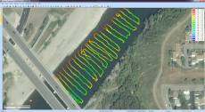
Eye4Software Hydromagic 7.0.15.929
Company: Eye4Software B.V. Country: Netherlands, OV, Delden ASP member: No Company Web site: http://www.eye4software.com Site of program: http://www.eye4software.com/hydromagic Application info: http://www.eye4software.com/hydromagic Author: Leon Steijger Sales email: eyesoftware.pad@submitpad.org Support email: eyesoftware.pad@submitpad.org License type: Demo Class: Business::Math & Scientific Tools Specific: Business Categories: Business & Finance :: CAD, Education :: Science, Multimedia and Design :: CAD Platform: Windows OS: Win2000, WinXP, Win7 x32, Win7 x64, Windows 8, Windows 10, WinServer, WinOther, WinVista, WinVista x64 System requirements: Windows XP SP3 or higher Language: English Limitations: Exporting and printing functions disabled in demo version
Keywords: Hydrographic Survey Software, Hydrographic Software, Hydrographic Survey, Bathymetry, Seafloor Mapping Software, Hydrographic Data Acquisition, Dredging Volume Calculation, Volume Calculations, Bathymetric Software, Single Beam Data Collection
Report Malware VT
~1549.93$
Date Version Status Release history 09 Oct 2015 7.0.15.929 Major Update Improved data collection module, support for latency, added device plugins for motions sensors and total stations.
Distribution permissions: The trial version of MySoftware can be freely distributed over the internet in an unchanged form
EULA http://www.eye4software.com/hydromagic/documentation/license-agreement/
Ratio:
Back Top
December 2025
Su Mo Tu We Th Fr Sa
1 2 3 4 5 6
7 8 9 10 11 12 13
14 15 16 17 18 19 20
21 22 23 24 25 26 27
28 29 30 31
14 December 2025 year, Sunday
Online
Guests: 3


 Gallery


 Eye4Software Hydromagic 7.0.15.929