
 Gallery


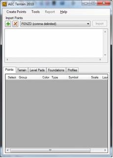
 AEC Terrain 2.0
|
|
World Software Catalog
Internet catalog of free and paid applications of the World
|
RU EN
|
Software search
AEC Terrain 2.0
AEC SOFTWARE v.1.0.1 2013 AEC SOFTWARE LICENSE TERMS ======================== Please read carefully the following license terms relating to the agreement between __________________________________________________________________________(You /The user) And AEC Logic Pvt Ltd(or one of its affiliates, based on the location) These terms apply to the software named above, which includes the media on which you received it, if any. The terms also apply to all Updates Supplements Internet-based services, and Support services Belonging to the AEC software, unless other terms are mentioned therewith. These license terms supersede the license terms embedded in the software. By installing, having installed, or using the software, you accept these terms. If you do not accept, you cannot install or use the software.If you comply with these license terms, you have the below rights: 1. LICENSE MODEL The software is licensed based on the number of users. The users are divided into two types based on the access provided to them: Generic Users: The users who can use the software with free license with limited access. Functional Users: The users who are into the main stream operational activities like management, financial etc., Note: The complimentary applications offered are also provided with an exclusive license each. 2. DEFINITIONS “You” means the legal entity that has agreed to these license terms and your affiliates; “Affiliate” means any legal entity that owns, is owned by, or that is under common ownership with a party; “Ownership” means more than 50% ownership; “Client software” means the software that allows a single personal computer, workstation, terminal, handheld computer, personal digital assistant, or other electronic device(s) to access or use the software or to use certain aspects of the server software when disconnected from the server; “Server software”means the software that provides services or functionality on your server (your computer is capable of runningthe server software are “servers”); “System database” means the underlying database that controls your users and reporting units; “Generic User” means a named user, who accesses your system database indirectly for purposes of using a limitedset of services or functionality. “Functional User” means a named user, who accesses your system database indirectlyfor purposes of completing the tasks that are supposed to work outthrough the software. 3. INSTALLATION AND USE RIGHTS a. Server Software. You may install an unlimited number of copies of the software to access your system Database. However, you may only use the number of copies that your license key permits. You may not duplicate license keys without AEC Logic’s prior written consent. b. Client Software. You may install an unlimited number of copies of the client software. However, you may use the client software only with the server software. That is, you may install an unlimited number of copies of the AEC software you have licensed for your system. You must obtain a separate license for each type of AEC software if you wish to install an additional component for multiple systems. You may not duplicate license keys without AEC Logic’s written consent. 4. ADDITIONAL LICENSING REQUIREMENTS AND/OR USE RIGHTS a. User Licenses In addition to the software license, you must acquire user licenses for the total number of users that access the system directly or indirectly. You may license functional users, generic users depending on the type of access to the system that the user requires. For users that are your or your affiliates’ employees, contractors or agents, you must license functional users. You may select the Generic User or the Functional user as named user types. If you select the Functional user, your use of this Named user license is subject to those restrictions listed in the Functional user definition. You may permanentlyre-assign your named user from one user to another; b. External Connector Licenses You must assign each external connector license you acquire to a system database. Each external connector license assigned to a system database permits any number of third party users to access that system database. You do not need named users. c. Third Party Hosting You may have a third party host the software on your behalf solely for access by you andyour affiliates. You may not permit your third party hosting vendor to allow access to the software by unaffiliated third parties except as otherwise allowed through an external connector license. Your third party hosting vendor must agree to be bound by these terms. d. License Grant for Templates You may copy and use templates provided with the software and identified for such use in documents and projects that you create. You may distribute those documents and projects non-commercially. e. Modification Disclaimer You may modify the software only as necessary to use it for your internal business purposes if you received it in source code form or you or any third party acting on your behalf have licensed tools from AEC Logic that allow you or that third party acting on your behalf to modify the object code form. You agree that AEC Logic is not responsible for any problems that result from modifications made by you, a partner, or anyother third party acting on your behalf, or any problems that are caused by third party hardware or software. AEC Logic does not, and will not have any obligation to, provide technical or other support for any modificationsmade by you, a partner or any other third party. AEC Logic does not make any representation, endorsement, guarantee or assurance of the suitability of the software for your business, the suitability of the partner or any otherthird party to create modifications or to implement the modifications or the software, or that any modificationcreated, implemented, supported and/or serviced by, for or on behalf of you or any third party will meet your business needs or operate successfully with the software. AEC Logic and its partners are independent entities and AEC Logic is not liable for nor bound by any acts of such business partners. f. Additional Functionality AEC Logic may provide additional functionality for the software. Other license termsand fees may apply. g. Complex Software The software is complex computer software. Its performance will vary depending on yourhardware platform, software interactions, the configuration of the software and other factors. The software is neither fault tolerant nor free from errors, conflicts or interruptions. 5. INTERNET-BASED SERVICES AEC Logic provides Internet-based services with the software. AEC Logic may change or cancel them at any time. a. Consent for Internet-Based Services Certain features in the software may connect to AEC Logic or third partyservice provider computer systems over the Internet. In some cases, you will not receive a separate notice when they connect. You may switch off these features or not use them. For more information about these features, see the software documentation. By using these features, you consent to the transmission of this information. AEC Logic does not use the information to identify or contact you. b. Computer Information Certain features in the software use Internet protocols, which send to the appropriatesystems computer information, such as your Internet protocol address, the type of operating system, browser, name and version of the software you are using, and the language code of the device where you installed the software. AEC Logic uses this information to make the Internet-based services available to you. Some of these features include, but are not limited to- Web Content Features. Features in the software can retrieve related content from AEC Logic and provide it toyou. To provide the content, these features send to AEC Logic the type of operating system, name and version of the software you are using, type of browser and language code of the device where you installed the software. c. Use of Information AEC Logic may use the device information, error reports, and malware reports to improve our software and services. We may also share it with others, such as hardware and software vendors. They may use theinformation to improve how their products run with AEC Logic software. d. Misuse of Internet-based Services You may not use these services in any way that could harm them or impairanyone else’s use of them. You may not use the services to try to gain unauthorized access to any service, data,account or network by any means. 6. BENCHMARK TESTING You must obtain AEC Logic's prior written approval to disclose to a third party the results ofany benchmark test of the software. 7. SCOPE OF LICENSE The software is licensed, not sold. This agreement only gives you some rights to use thesoftware. AEC Logic reserves all other rights. Unless applicable law or a separate written contract with AEC Logic givesyou more rights despite this limitation, you may use the software only as expressly permitted in this agreement. Indoing so, you must comply with any technical limitations in the software that only allow you to use it in certain ways.You may only use the software for your internal business purposes. You may not Work around any technical limitations in the software; Reverse engineer, decompile or disassemble the software, except and only to the extent that applicable law expressly permits, despite this limitation; Make more copies of the software than specified in this agreement or allowed by applicable law, despite this limitation; Publish the software for others to copy; Rent, lease or lend the software; or Use the software for commercial software hosting services. Your rights to use the software are perpetual but may be revoked if you or your affiliates do not comply with the terms of this agreement. Rights to access the server software do not give you any right to implement AEC Logic patents orother AEC Logic intellectual property in software or devices that access the server. 8. BACKUP COPY You may make multiple copies of the software for backup, development and testing purposes, so longas such copies are not used in production and the development is for your internal use only. Your backup copies maybe hosted by a third party on your behalf. 9. FAIL-OVER RIGHTS You may run a single passive fail-over instance of your system database for temporary support. 10. LICENSE TRANSFER You may not transfer the software to a third party without AEC Logic’s prior written consent. If permitted, there may be additional charges for transferring the software to a third party. 11. DOCUMENTATION Any person that has valid access to your computer or internal network may copy and use the documentation for your internal, reference purposes. 12. DOWNGRADE Instead of installing the software, you may install and use an earlier version. This agreement applies to your use of the earlier version. If the earlier version includes different components, any terms for those components in the agreement that comes with the earlier version apply to your use of them. AEC Logic is not obligated to supply earlier versions to you. At any time, you may replace an earlier version with this version of the software. 13. EXPORT RESTRICTIONS The software is subject to Indian export laws and regulations. You must complywith all domestic and international export laws and regulations that apply to the software. These laws include restrictions on destinations, end users and end use. 14. SUPPORT SERVICES AEC Logic provides support services for the software as described at www.aeclogic.com 15. LOCALIZATION AND TRANSLATION AEC Logic provides localizations and translations for the software 16. ENTIRE AGREEMENT This agreement (including the warranty below), and the terms for supplements, updates,Internet-based services and support services that you use, are the entire agreement for the software and supportservices. 17. APPLICABLE LAW a. Indian. If you acquired the software in Indian law governs the interpretationof this agreement and applies to claims for breach of it, regardless of conflict of laws principles. The laws of thestate where you are located govern all other claims, including claims under state consumer protection laws, unfair competition laws, and in tort. b. Outside India If you acquired the software in any other country, the laws of that country apply. c. Attorneys’ Fees and Costs If you or AEC Logic files a lawsuit, brings an action or otherwise pursues a claimagainst the other in connection with or arising out of this agreement or the software, the prevailing party will beentitled to recover its reasonable attorneys’ fees, costs and other expenses (including any appeal). 18. LEGAL EFFECT This agreement describes certain legal rights. You may have other rights under the laws of your stateor country. You may also have rights with respect to the party from whom you acquired the software. This agreementdoes not change your rights under the laws of your state or country if the laws of your state or country do not permit itto do so. 19. DEFENSE OF INFRINGEMENT AND MISAPPROPRIATION CLAIMS AEC Logic will defend you against any claims made by an unaffiliated third party that the software infringes its patent, copyright or trademark or misappropriates its trade secret, and will pay the amount of any resulting adverse final judgment (or settlement to which AEC Logic consents).You must notify us promptly in writing of the claim and give us sole control over its defense or settlement. You agree to provide us with reasonable assistance in defending the claim, and AEC Logic will reimburse you for reasonable out ofpocket expenses that you incur in providing that assistance. Our obligations will not apply to the extent that the claim or adverse final judgment is based on (i) your use of thesoftware after AEC Logic notifies you to discontinue use due to such a claim; (ii) your combining the software with a non-AEC Logic product, data or business process including third party add-ons or programs; (iii) damages attributable to thevalue of the use of a non-AEC Logic product, data or business process; (iv) your altering or modifying the software,including any modifications by third parties; (v) your distribution of the software to, or its use for the benefit of, anythird party; (vi) your use of AEC Logic trademark(s) without express written consent to do so; or (vii) for any trade secretclaim, your acquiring a trade secret (a) through improper means; (b) under circumstances giving rise to a duty tomaintain its secrecy or limit its use; or (c) from a person (other than AEC Logic or its affiliates) who owed to the partyasserting the claim a duty to maintain the secrecy or limit the use of the trade secret. You will reimburse us for anycosts or damages that result from these actions. If AEC Logic receives information concerning an infringement or misappropriation claim related to the software, AEC Logic may, at its expense and without obligation to do so, either (i) procure for you the right to continue to run the software, or (ii) modify the software or replace it with a functional equivalent, to make it non-infringing, in which case you willstop running the software immediately. If, as a result of an infringement or misappropriation claim, your use of thesoftware is enjoined by a court of competent jurisdiction, AEC Logic will, at its option, either procure the right to continueits use, replace it with a functional equivalent, modify it to make it non-infringing, or refund the amount paid andterminate this license. If any other type of third party claim is brought against you regarding AEC Logic’s intellectual property, you must notifyus promptly in writing. AEC Logic may, at its option, choose to treat these claims as being covered by this section. ThisSection 20 provides your exclusive remedy for third party infringement and trade secret misappropriation claims. 20.LIMITATION ON AND EXCLUSION OF DAMAGES You can recover from AEC Logic and its suppliers onlydirect damages up to the amount you paid for the software except for claims covered by Section 19. You cannot recover any other damages, including consequential, lost profits, special, indirect or incidental damages. This limitation applies to Anything related to the: (i) software, (ii) services, (iii) content (including code) on any third party Internet sites, or(iv) third party programs; and Claims for breach of contract, breach of warranty, guarantee or condition, strict liability, negligence, loss of data,damage to records or data, loss of goodwill, loss as a consequence of a business interruption or any other tort tothe extent permitted by applicable law. It also applies even if Repair, replacement or a refund for the software does not fully compensate you for any losses; or AEC Logic knew or should have known about the possibility of the damages. Some jurisdictions do not allow the exclusion or limitation of incidental or consequential damages, so the abovelimitation or exclusion may not apply to you. 22. VERIFYING COMPLIANCE a. Right to verify compliance You are required to keep records (including proof of purchase) relating to thesoftware you and your affiliates use under this agreement. AEC Logic has the right to verify compliance with thisagreement, at AEC Logic’s expense. You agree to provide reasonable cooperation in the event of a compliance audit. AEC Logic may request that you grant your consent to allow access to the usage information captured by the system as a tool in conducting the audit. b. Verification process and limitations To verify compliance, AEC Logic will engage an independent accountantfrom an internationally recognized public accounting firm, which will be subjected to a confidentialityobligation. Verification will take place upon not fewer than 30 days’ notice, during normal business hours and in amanner that does not interfere unreasonably with your operations. As an alternative, AEC Logic can require you tocomplete AEC Logic’s self-audit questionnaire relating to the software you and any of your affiliates use under this agreement, but reserves the right to use a verification process as set out above. If AEC Logic undertakes verification and does not find material unlicensed use (license shortage of 5% or more) AEC Logic will not undertake another verification of the same entity for at least one year. AEC Logic and AEC Logic’s auditors will use the information obtained in compliance verification only to enforce AEC Logic’s rights and to determine whether you are in compliance with the terms of this agreement. By invoking the rights and procedures described above, AEC Logic does not waive its rights to enforce this agreement or to protect its intellectual propertyby any other means permitted by law. b. Remedies for non-compliance If verification or self-audit reveals any unlicensed use, you must promptly ordersufficient licenses to cover your use. If material unlicensed use is found, you must reimburse AEC Logic for the costs AEC Logic has incurred in verification and acquire the necessary additional licenses at single retail license cost within30 days. †††††† Ratio: Back Top
New on site
|
User
RSS-feed
Online
Guests: 2
Users: 0 Bots: 16 Total users: 95 Banners
|
||||||||||||||||||||||||||||||||||||||||||||||||||||||||||||||||||||||||||||||||||||||||||||||||||||||||||||||||||||||||||||||||||||||||||||||||||||||||||||||||||||||||||||||||||||||||